
BPC00003
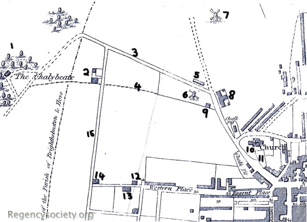
Map from Baxter’s Stranger in Brighton guide, published 1824, but the map, by W. Belch, is dated 1822. The map shows the west side of Church Hill that is now the residential area of Powis and Clifton, south of the Seven Dials. The following numbers pick out particular details.
1: The Chalybeate, now St. Ann’s Well Gardens
2: The Temple, home of T.R. Kemp, now the Brighton and Hove High School on Montpelier Road.
3: The Road to Blatchington, now Clifton Hill.
4: The track-way that has become Victoria Road.
5: A late Georgian soap manufactory owned by a Mr. Edward Heard, which in the spring of 1822 was converted into the Church Hill School, run by the Rev. Airey. This area later became the site of the Royal Alexandra Children’s Hospital on Dyke Road, which has since been converted into residential flats.
6: Vine’s Mill, the location of this mill was in the back gardens of numbers 6 and 7 Powis Villas.
7: Hudson’s Mill, where West Hill Road is today.
8: The Church Hill Workhouse.
9: Vine’s Cottage, still on the corner of Vine Place and Dyke Road.
10: St. Nicholas’ Church.
11: The ground where Wykeham Terrace now stands.
12: Hampton Lodge, a bungalow mansion owned by the banker Henry Fauntleroy, near the corner of Hampton Place and Western Place (now Western Road).
13: Western Lodge, the home of Mrs. Ann Sober (T.R. Kemp’s sister). The house was situated on what is now Western Road near the corner of Sillwood Road (then called Western Cottages). Western Lodge was one of the few Brighton buildings painted by John Constable.
14: West Hill Lodge, the home of the Countess Dowager Gosford (situated where Waitrose is today).
15: Montpelier Road, probably established as a track-way to service Kemp’s Temple, which was built by 1819. The road was probably still un-named at the date of this map, and note that it had no northward continuation beyond the Road to Blatchington (No: 3) Roles & Beevers (A Pictorial History of Brighton, 1993) describe Montpelier Road as being developed in stages from the 1820s.
All maps: (click on image to see the full entry)
View all galleries on the galleries page
Hover over the image to see the image number followed by the date when the image was produced.
Click on any image to see its full entry.


